- Date added:
- Aug 22, 2022 | Last update check: 1 minute ago
- Integrations:
- —
- Licence:
- Trial | Buy Now
- Runs on:
- Revit 2019 / 2020 / 2021 / 2022 / 2023
LTM – Landscape Terrain Modeller is a Revit add-on for landscape architects developed by Danish architectural firm Aarstiderne Arkitekter. It spreads Revit functionality into the field of landscape architecture. You can automate the processes that you performed manually.
Landscape Terrain Modeller includes 12 tools to edit floors e.g. converting toposurface to floor and 4 tools to improve the representation on plan drawings. With LTM you can edit and insert sub-elements in floors, create filled regions connected with floors, and generate floors from toposurface. It only works with floors and openings that are created in one closed loop.
The full list of functions:
Modify floors
- Create Sub Element by typing slope – point out the start and endpoint.
- Create Sub Element by typing slope – point out the start and endpoint with the endpoint on a different floor.
- Match Sub Element by aligning Sub Elements (with or without offset) in two floors sharing edges.
- Adjust Sub Elements – adjust all sub-elements in a selected area.
- Sub Elements in Real Level – set the sub-elements in reel levels and not relative to the floor level.
- InFill floor – Create/update a floor inside an opening on another floor.
- Unify Slope – extending a slope between two points and a third point.
- Match Floor to Grading – adjust the floor to match the corners of a grating.– Find Coordinate – creating a cross with coordinates at a specific coordinate.
- Sketch Annotation to floor – Convert Sketch annotations to a vertex in floors or Toposurfaces.
- Match floor to object – Match the elevation on floor vertexes with imported IFC/DWG.
- Match point to object – Match/Set the elevation on a single point on floor vertexes with imported IFC/DWG.
- Match Curbs to element – Match the elevations of curbs from the attached floor.
Create Filled Regions attached to floors
- Create a Filled Region – create a filled region with the same shape as the floor.
- Clone Filled Region – clone filled regions from another view and preserve the connection to the floor.
- Update Filled Regions – if the shape of the floor is changed all filled regions will adjust to the new shape.
- Update by Selection – the selected filled region is updated.
Calculations
- Cut/Fill SubSoil – calculate cut/fill volume between floors and toposurface.
Toposurfaces
- Import Model Lines – import model lines from DWG, in the right level and line style.
- Change style & elevation – match line style and elevation.
- Offset Lines – create contour lines between 2 selected lines.
- Elevation texts – place texts on the selected contour lines showing the Z Value.
- Elevation info – showing the Z Value or placing a text on the selected line.
- Create toposurface – Create toposurface on selected model lines.
- Toposurface to Floor – create a floor from the information in a Toposurface.
- Building on Toposurfaces – Move buildings to the right level on the toposurface.
Annotations
- Sketch New Annotation – Create new Sketch Spot elevation, using the slope in the LTM Menu.
- Sketch Interpolation – Create new Sketch Spot elevation, using interpolation between two Sketch elevations.
- Sketch Slope – Insert text showing the slope between two Sketch elevations.
- Update Sketch Slope – Update text showing the slope between two Sketch elevations.
- Place Annotation – Place an annotation and type the elevation.
- Place Annotation 3D – Place an annotation getting the elevation from the selected object.
QA
- Slope Texts – creating slope texts on selected floors (colored by Min- and Max slope).
Analysis
- Slope – Coloring the faces depending on the slopes.
- Slope Min/Max – Coloring the faces depending on the floors Min/Max Settings.
Tools
- Objects on Lines – Insert Families along with a series of lines.
- Spot Elevation – creating Spot elevation on selected floors.
- Create Floor from bottom face – creating a floor on the bottom face of the object.
Import/Export
- DXF Export, export the surfaces and all layers to DXF format.
- Export Sketch annotations in csv format.
- Import data from CSV/Excel/DWG.
Known limitations:
- The functions will only work on Floors.
- Floors and openings must only be created in one closed loop.
- Floors with complex geometric forms can cause LTM not to compute.
- Some Topographies with complex forms can make it impossible to create the floor or edit the floor boundaries. Alternatively, these can be divided using Split Surface to avoid very large complex floors.
- Some Openings with complex forms or too many edges can make it impossible to create InFill floors.
- The DWG file used in the function Import Model must NOT be scaled inside Revit.
Version 6 updates (changelog)
- 6.3.0.0 Update. Support for Revit 2023.
What’s new in version 6:
- Match floor to element – Match the elevation on floor vertexes with imported IFC/DWG.
- Match point to element – Match/Set the elevation on a single point on floor vertexes with imported IFC/DWG.
- Match Curbs to element – Match the elevations of curbs from the attached floor.
- Tools: Create Floor from bottom face – creating a floor on the bottom face of the object.
- Annotations: Place Annotation – Place an annotation and type the elevation.
- Annotations: Place Annotation 3D – Place an annotation getting the elevation from the selected object.
- Import/Export: DXF Export, export the surfaces and all layers to DXF format.
- Import/Export: Export Sketch annotations in csv format.
- Import/Export: Import data from CSV/Excel/DWG.
- Analysis: Slope – Coloring the faces depending on the slopes.
- Analysis: Slope Min/Max – Coloring the faces depending on the floors Min/Max Settings.
- Settings: More settings, Parameter names default Sketch annotation, colors for analysis.
About Aarstiderne Arkitekter
Årstiderne Arkitekter is a leading Scandinavian architecture firm with broad experience in architecture, design and construction. We are a full-service architecture firm founded in 1985 with 250 employees working from offices in Copenhagen, Silkeborg, Aarhus, Herning and Nesbyen in Norway.
In 2018 Årstiderne Arkitekter became part of Sweco – Europe’s leading architecture and engineering consultancy with 15.000 employees and 1.300 architects.
Gallery
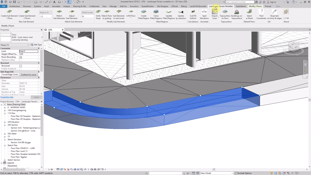
LTM – Landscape Terrain Modeller ribbon in Revit. ©Årstiderne Arkitekter